
Central Myanmar
- Mandalay
Mandalay, as the center of Myanmar culture, was outstanding in the past, it holds the stage now; and it will continue to be a place of pride in the future. It is situated about 600 kilometers north of Yangon on the Ayeyarwaddy river, is, with about half a Million inhabitants Myanmar's second largest city.
- Amarapura
Amarapura meaning "City of Immortality" is a city in the Mandalay Division of Myanmar, situated 11 km to the south of Mandalay. The locals sometimes refer to it as Taungmyo (Southern City) to distinguish it from Mandalay (Northern City).
- Innwa
Innwa was also known as Ava in the ancient times. It is a city in the Mandalay Division of Myanmar, situated just to the south of Amarapura on the Ayeyarwady River. It is also called Ratnapura meaning "City of Gems".
- Sagaing
Sagaing is the capital of Sagaing Division in Myanmar. It is located on the Ayeyarwady River, 20 km to the southwest of Mandalay on the opposite bank of the river.Sagaing is a religious and monastic center, with numerous Buddhist monasteries. It briefly regained is position as a royal capital of Burma from 1760-1764.
- Mingun
Mingun is a town in Sagaing Division, Myanmar, located 11 km up the Ayeyarwaddy River from Mandalay. A 45-minute boat trip to Mingun is very pleasant with plenty of life on the river to see.It is the site of two famous monuments - the Mingun Pahtodawgyi (unfinished pagoda) and the Mya Theindan Pagoda.
- Pyin Oo Lwin
Pyin Oo Lwin was formerly known as May Myo. It is a resort town in Mandalay Division in Myanmar, located some 67 kilometers east of Mandalay, and at an altitude of 1070 meters (3510 feet). It was initially a Shan village situated between Naungcho and Mandalay on the Lashio-Mandalay road.
- Monywa
Monywa is a city in Sagaing Division, Myanmar, located 136 km north-west of Mandalay on the eastern bank of the Chindwin River. It is along the Mandalay-Budalin branch railway line but is best reached by bus as the road from Mandalay is in reasonably good shape.
- Shwebo
Shwebo is a city in the Sagaing Region of Myanmar, located 64 miles (103km) north-west of Mandalay on the eastern bank of the Chindwin River. Shwebo was the native town of King Alaungpaya, the founder of the Kone Baung Dynasty.
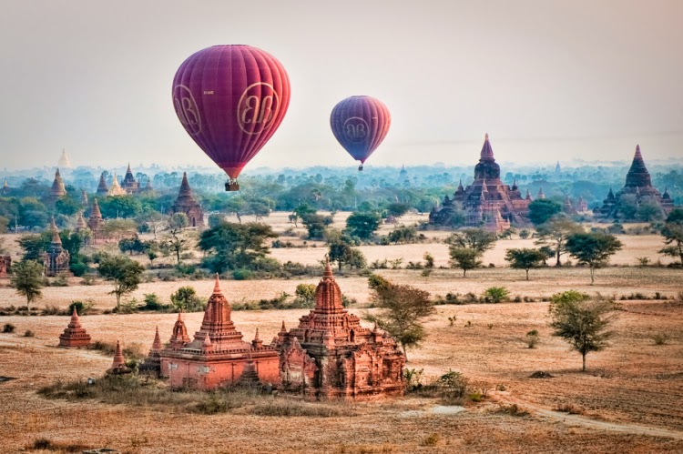
- Bagan
Bagan dates back almost to the beginning of the Christian Era. It lies on the bend of the Ayeyarwaddy River. Bagan can be marked to have started with King Anawrahta. He ascended the throne of Bagan in 1044.
- Salay
Salay is a colorful old religious center in Central Myanmar it is about 1 ½ hours south of Bagan. In between visiting the numerous ancient monasteries, adorned with beautiful woodcarving, you can enjoy the beauty of this compact city of colonial buildings, monasteries and pagodas.
- Mt.Popa
Mt. Popa is about 50km away from Bagan. It is about 45 minute drive from Nyaung Oo Airport, Bagan. Mt. Popa is an extinct volcano that is estimated to have erupted for the final time, over three hundred and twenty thousand years ago
- Taungoo
Taungoo is a city in the Bago Division of Myanmar, located 220 km from Yangon, towards the northern end of the division, with mountain ranges to both east and west. The main industry is in forestry products, with teak and other hardwoods extracted from the mountains.
- Nay Pyi Taw
Nay Pyi Taw is the administrative capital of the Republic of the Union of Myanmar. Centrally lovated, it is 391km from Yangon and 302km from Mandalay, being easily accessinle from all parts of the country. The environs of Nay Pyi Taw comprise (8) township viz.
- Pyay
Pyay (formerly Prome) in ancient times was known as Srikshetra (Thayaykhittaya). It is a town in the Bago Region in Lower Myanmar which is located 260km (162 mi) northwest of Yangon.
- Bago
Bago was formerly known as Pegu. It is a city and the capital of Bago Region in Myanmar. It is located 80 km (about 50 miles) from Yangon. It has a population of 220,000.
- Mogok
Mogok is a city in the Mandalay Division of Myanmar, located 200 km north of Mandalay and 148 km north-east of Shwebo. It is also known as the "Land of Gems".
North Eastern Myanmar
- Kalaw
Kalaw is situated in Shan State, Myanmar. Kalaw is a popular hill station of Myanmar. It is a peaceful and quiet place. At an altitude of 1320 metres it's also pleasantly cool and a good place for hiking and amid gnarled pines, bamboo groves and rugged mountain scenery.
- Pindaya
Pindaya, a three hour drive from Helo is a city located in the hills of the Shan State, the largest area within Myanmar. The cave is noted for its 9000 Buddha statues, but is also a bustling market town located on a small lake.
- Nyaung Shwe
Nyaungshwe is a small town at the northern end of the Inlay Lake. There are many Major attractions......
- Inle Lake
Inle Lake is 22km long and about 11km wide. The lake is at 1328 metres above sea level. Inle is one of the most popular tourist destination in the Shan State.
- Taunggyi
Taunggyi is the capital city of Shan State. Shan State is the largest state in Myanmar and hence Taunggyi is an important city of trade. It is 1430 meters above sea level. Taunggyi meaning "The huge mountain" in Myanmar.
- Kakku
The Kakku relic pagoda of the southern Shan state, which only recently has become one of the most visited places in the Shan State. It is situated near Mway Taw Village, Kakku village tract, Taunggyi township, under the administration of special region 6, About 25 KM away from Taunggyi, the Capital of Shan State.
- Aungban
Aungban is located at 4219ft (1286m) above sealevel,38 miles (61km) away from Taunggyi and 6 miles (10km) away from Kalaw. Aungban is an important town for farmers because it is a junction of Pindaya, Kalaw, Taunggyi.
- Hopone
Ho Pone is believed to be an ancient town and the residents are mainly Shan and Pa-O. It is located 12 miles (19km) away from Taunggyi on the way to Hten San Cave. The most famous religious site is the Shwechanthar Pagoda and Ho Pone pond is also a beautiful spot.
- Kyaing Tong
Kyaing Tong is about 456km from Taunggyi, the capital city of Shan State. Kyaing Tong is inhabited by ethnic tribes such as Wa, Shan, Akha and Lahu. Kyaing is full of temples, colonial buildings, lakes and is the most scenic town in Shan State. Kyaing Tong also carries the definition of "Walled City of Tung".
- Tachileik
Tachilek is the easternmost town in the country and enjoys the fame of anchoring the Myanmar end of the Golden Triangle, a term which made its entry into print during the Vietnam war.
- Lashio
Lashio is in a mountain basin at 855 meters. The weather is wet, since clouds may form and deliver rain just about any time of the year. Lashio is basically divided into Lashio Gyi and Lashio Lay districts.
- Muse
Muse is located 247 miles (398km) far from Mandalay, a small town on the bank of the Shwe-li River. Muse is the main border gateway of Myanmar and China. There are many car lines from Mandalay to Muse.
- Myitkyina
Myitkyina is the Capital city of Kachin State. The town is situated in a flat valley that becomes extremely hot in the hot season and very rainy during the monsoon. There is an abundance of fruit in this state.
- Putao
Putao is a town far north of the Kachin State. Putao is close to the Hkakaborazi Mountain, the highest mountain in Myanmar. Hkakaborazi means snowcapped year round. It is 5889 meters high.
- Loikaw
Loikaw has a population of about 11,000 and it is the capital of Kayah State in Myanmar. It is located near the State’s northern tip, at an elevation of 1200 meters.
- Thipaw
Thipaw also known as Hsipaw, is a well know town in Shan State, Myanmar. It is 200km or about 124 miles northeast of Mandalay, lying at 1370ft (418m) above sea level. There are several interesting sites around the Dokhtawaddi River, very peaceful and quiet.
South Eastern Myanmar
- Kyaikhtiyo
Kyaikhtiyo Pagoda is located in Mon State. It is about 20kms from the town Kyaikhto. It is a 7.3 meters pagoda on top of a big "Golden Rock". The massive golden boulder is right on top of the Kyaikhto mountain. Legend say that the boulder maintains its precarius balance due to a precisely placed Buddha hair inside the pagoda. Once there was a King who received the Buddha's hair in the 11th century from a hermit.
- Mawlamyaing
Mawlamyaing is the capital city of the Mon State and a big trading centre of Myanmar. The city's population is about 300,000 and consists of Mon, Kayin, Bamar, Indians and some Chinese. Mawlamyaing is the third largest city in the country and is the second largest seaport.
- Mudon
Mudon is a town in the Mon State in the southeast Myanmar. It is known for its large reclining Buddha.
- Kyaikkami
The village of Kyaikkhami is 15 miles (24km) from the town of Thanbyuzayat and is famous for the pagoda of the same name which is located on a reef about 900 feet (274m) from the sea shore and thus usually called Ye Lel Paya, "pagoda amidst water".
- Setse Beach
It lies 24km south of Kyaikkami and 16km southwest of Thanbyuzayut, Mon State. It is a very wide, brown-sand beach that tends toward tidal flats when the shallow surf-line recedes at low tide. The beach is lined by waving casuarinas trees.
- Thanbyuzayat
The name of the town is taken from a not-too-long rest house roofed with galvanized iron standing near the marketplace. A war memorial here holds the graves of 3,770 British, Australian, Dutch and Gurkha prisoners-of-war who died while constructing the infamous "death railway" under supervision of Japanese forces during the Second World War.
- Myeik Archipelago
The Myeik Archipelago covers an area of about 36,000 square kilometres in the southern most part of Myanmar. There are about 800 islands in this area making this place an attractive tourist destination.
- Thatone
It is one of the best known towns in Mon State. lt is said that it was once an insignificant village peopled by the Lawa. Later, Mon and Pa O came to settle and maritime intercourse with south Indian states brought about its development into a thriving city. However, there is another contention that it was the first city to be founded by the Mon people.
- Hpa-an
Hpa An is the capital of Kayin State. The city is connected to other towns like Kawkareik, Hpapun and Myawaddy by roads and waterway transportation. The singularly distinctive limestone pinnacle forming the Zwegabin Mountain provides a dramatic backdrop for Hpa An. The Kayin people are very fond of the color red, which can be seen on most of the men and women clothing.
- Maungmagan Beach
Maungmagan beach is located in Tanintharyi Division near Dawei, the capital city of the state. The scenic Maungmagan beach is approximately 45-minutes drive away from Dawei.
- Dawei
Dawei, in Tanintharyi Division, is a coastal region lies in Southern part of Myanmar with an area of more than 2,600 square miles. Various nationalities such as Bamar, Mon, Kayin, Rakhine and Shan totalling over 120,000 are residing in Dawei. Formerly the city was known as "Tavoy".
- Myeik
Myeik is a town located in Tanintharyi Division of Myanmar, which is situated on the southern most part of the country.
- Kawthaung
Kawthaung was known as the "Victoria Point". It lies on the southern most part of Myanmar. The city is about 800 km from Yangon. Kawthaung retains the atmosphere as fishing port city.
Western Myanmar
- Ngapali Beach
Ngapali Beach is the most beautiful beach among the beaches in Myanmar. Its beautiful sandy beach stretches on the Bay of Bengal and it lies in Rakhine State of Myanmar. Apart from the normal beach activities, excursions like visiting the small fishing villages and local markets; exploring the countryside by bicycle and a boat trips to the magnificent ....
- Thandwe
Before Thandwe was known as "Sandoway". It is located around 9.5 km northeast of Ngapali Beach. Thandwe has the Airport which is the main gateway to the Rakhine State.
- Mrauk U
Mrauk U was once, one of the most powerful kingdom in history. The Rakhine King "Min Saw Mon" founded Mrauk U in 1433. Mrauk U was a leading trade city during its time, and abundant networks of canals allowed small and large vessels to go by.
- Sittwe
Sittwe is the port city of Rakhine State. It sits on the mouth of the Kaladan River where it empties into the Bay of Bengal. People here have the enjoyment of much spicier foods and brigher clothing.
- Kantharyar Beach
Kantharyar Beach is the Rakhing State's third pleasant beach resort. Kantharyar by its name meaning the pleasant beach in Myanmar. The beach is about 2km long. This beautiful beach was unveiled on 24th March, 1995 in commemoration of the 50th Golden Jubilee Myanmar Armed Forces Day.
- Chin State
Most of the traditional villages in the Chin area are found along the side of remote hills, near the fields. Long hikes straight down and then straight up are required to reach most of these villages.
- Lahe (Naga Village)
Lahe is a town on Naga Hills of Sagaing Region on the northwest of Myanmar. The Naga New Year Festival is held in Lahe, Layshi, Hkamti and Nanyun as hosts in rotation.
- Layshi (Naga Village)
Layshi is a town in Naga Hills of Sagaing Region on the northwest frontier of Myanmar. The Naga New Year Festival is held rotationally in Lahe, Layshi, Hkamti and Nanyun.
Delta Region
- Yangon
The brothers returned home and made landfall at Pagoda Point in the south-west coast of Myanmar. They sent word to king Ukkalapa of their arrival with the sacred Hairs. The King welcomed the Hairs with great ceremony at Asitanzana, north-west of present Yangon. The king and the brothers next sought for a man who could tell them the location of Singuttara Hill.
- Thanlyin & Kyauktan
Thanlyin was formerly known as Syriam. Myanmar usually pronounce as "Tanyin". It is a city in Yangon Division in Myanmar. It is located on the bank of Yangon River, and is a major port.
- Twante
Twante is situated 24km from Yangon and a boat trip along the Twante Canal takes about two hours. It is also accessible by car. It is noted for its pottery and cotton-weaving industries. Visitors get a chance to see the rural life along the famous canal of Twante.
- Pathein
Pathein (formerly known as Bassein) is a city (1983 pop. 144,092) and the capital of Ayeyarwaddy Region, Myanmar. Lying at the western edge of the Ayeyarwaddy river delta, on the Pathein (Ngawan) River 190 km west of Yangon, Pathein is accessible to large vessels and despite its distance from the ocean,
- Chaung Thar Beach
Chaung Thar Beach is one of the popular beaches in Myanmar. Located just 6 hours drive from Yangon. An alternative route is an overnight steamer trip from Yangon, along Twante canal up to Pathein and then a one and a half hour drive by coach to Chaung Thar Beach.
- Ngwe Saung Beach
Ngwe Saung is also on the western coast of Myanmar on the Bay of Bengal, nearly directly west of Yangon and a bit south of Ngapali.


No comments:
Post a Comment